It is no secret that the geographical features of South Africa are not only unique, but full of drama. From deep canyons to towering cliffs and cascading waterfalls, these landforms tell the story of millions of years of geological change. These beautiful spaces are also natural classrooms to see the wonders of geography in action.
Many of the South African geographical features that you read about in school textbooks are surprisingly accessible. Whether you live in Johannesburg, Cape Town, Durban, or a small Karoo town, there is always a striking landscape not too far away.
If you are helping a learner with geography or natural sciences, visiting these places can transform theory into something real. Just imagine how standing in front of a canyon wall or watching water tumble over a cliff can help someone to understand how the land has evolved.


What is a Canyon or Gorge?
Before exploring the most famous landscapes, it helps to understand a few key terms. First, a canyon or gorge forms when a river cuts deeply into the land over a very long period of time. The constant movement of water slowly erodes rock layers, carving steep sided valleys.
South Africa has many of these formations because the land sits on an ancient geological foundation. Over millions of years, rivers have gradually shaped the terrain to create the most remarkable geographical features.
One of the best known examples is the Blyde River Canyon. Located along the Panorama Route in Mpumalanga, it is widely regarded as one of the largest green canyons in the world. Unlike desert canyons, this one is covered in dense vegetation thanks to the region’s rainfall and climate.
Standing at viewpoints like God's Window, you can see layers of rock stretching across the valley. These rock layers show how geographical features develop through erosion and shifting climates.
The Blyde River Canyon
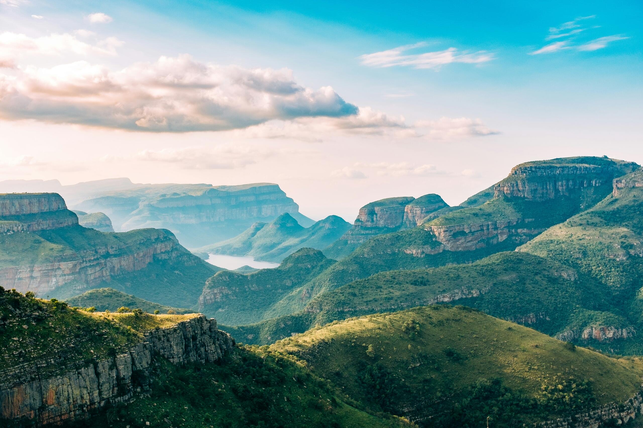
Stretching for about 26 kilometres, the canyon is carved by the Blyde River as it winds through the escarpment. The area is part of the Drakensberg Escarpment, where high plateau land suddenly drops toward the Lowveld.
Many learners from schools in Mbombela and Hoedspruit are conveniently located to visit the canyon during geography field trips. Here, teachers often use the site to explain rock strata, erosion, and how river systems shape the land.
Popular viewpoints include:
Three Rondavels
Bourke's Luck Potholes
God's Window
These formations show how geographical features have been sculpted by water over long periods of time.
If you enjoy learning about landscapes like these, you might also find our article on the escarpments and mountains in South Africa fascinating. This article explains how the country’s high mountain edges influence rainfall, rivers, and the formation of canyons.
Augrabies Gorge and the Orange River
Another spectacular location lies in the Northern Cape at Augrabies Falls.
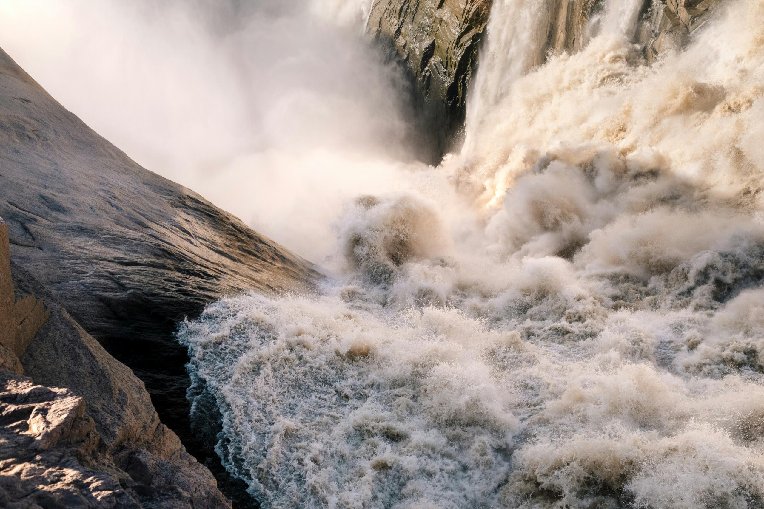
Here, the powerful Orange River plunges dramatically through a rocky gorge, creating one of the country’s most impressive waterfalls. The local Nama name translates roughly to “place of great noise”, which becomes obvious when you hear the water crashing into the canyon below.
The Orange River South Africa is the longest river in the country and over thousands of years, its strong currents carved the surrounding granite rocks into a deep canyon that now forms part of Augrabies Falls National Park.
For visitors to this area, it is quickly evident how the powerful flow of water gradually erodes rock and transports sediment downstream.
from its source in the Drakensberg Mountains in Lesotho to its mouth at the Atlantic Ocean on the border between South Africa and Namibia.
Many schools in the Northern Cape organise educational trips to Augrabies for learners to observe river erosion and canyon formation. Here, geography students will often sketch the gorge and study how the river continues to shape the surrounding land.
If you want to explore the country’s waterways in more detail, The Lakes and Rivers of South Africa explains how systems like the Orange River South Africa support agriculture and settlements.
A Waterfall that Falls into the Ocean
One of the most unusual South Africa geographical features can be found along the Wild Coast in the Eastern Cape.
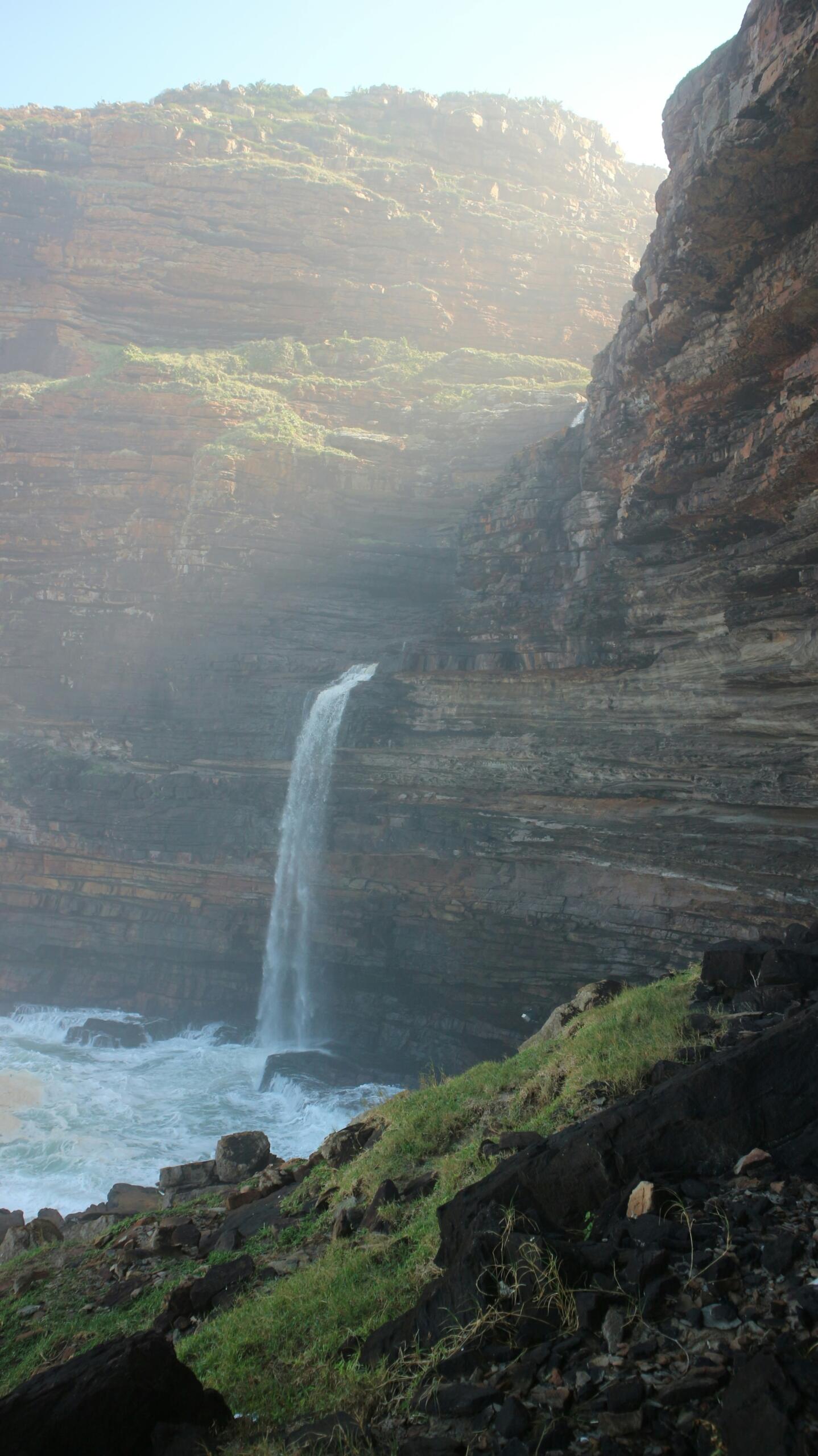
Waterfall Bluff in the Eastern Cape (left) is one of the few places in the world where a waterfall flows directly into the sea. Here, fresh water from the river spills over coastal cliffs before plunging into the Indian Ocean.
This makes it one of the most remarkable South African waterfalls. The site is located near the village of Lusikisiki and can only be reached by hiking along the rugged coastline.
For photographers and hikers, it is considered one of the most beautiful waterfalls in South Africa and the contrast between the ocean waves and falling freshwater is unforgettable.
The cliffs surrounding Waterfall Bluff also reveal layers of rock that help geologists understand the region’s history. These dramatic coastal landforms highlight how erosion by both rivers and the sea contributes to South Africa's geographical features.
Famous Waterfalls across the Country
Waterfalls appear wherever rivers flow over steep drops in the land and because South Africa has many escarpments and rocky plateaus, the country is home to numerous cascades.
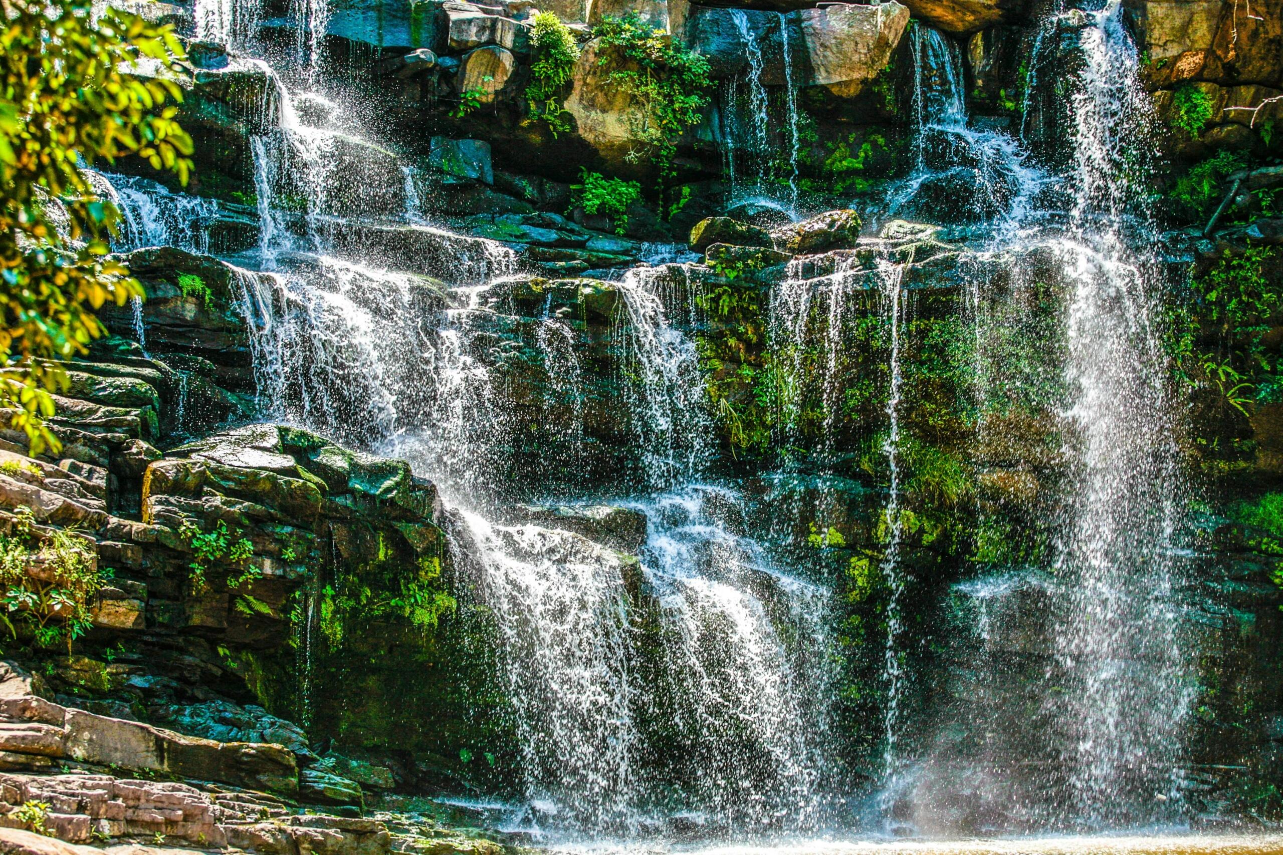
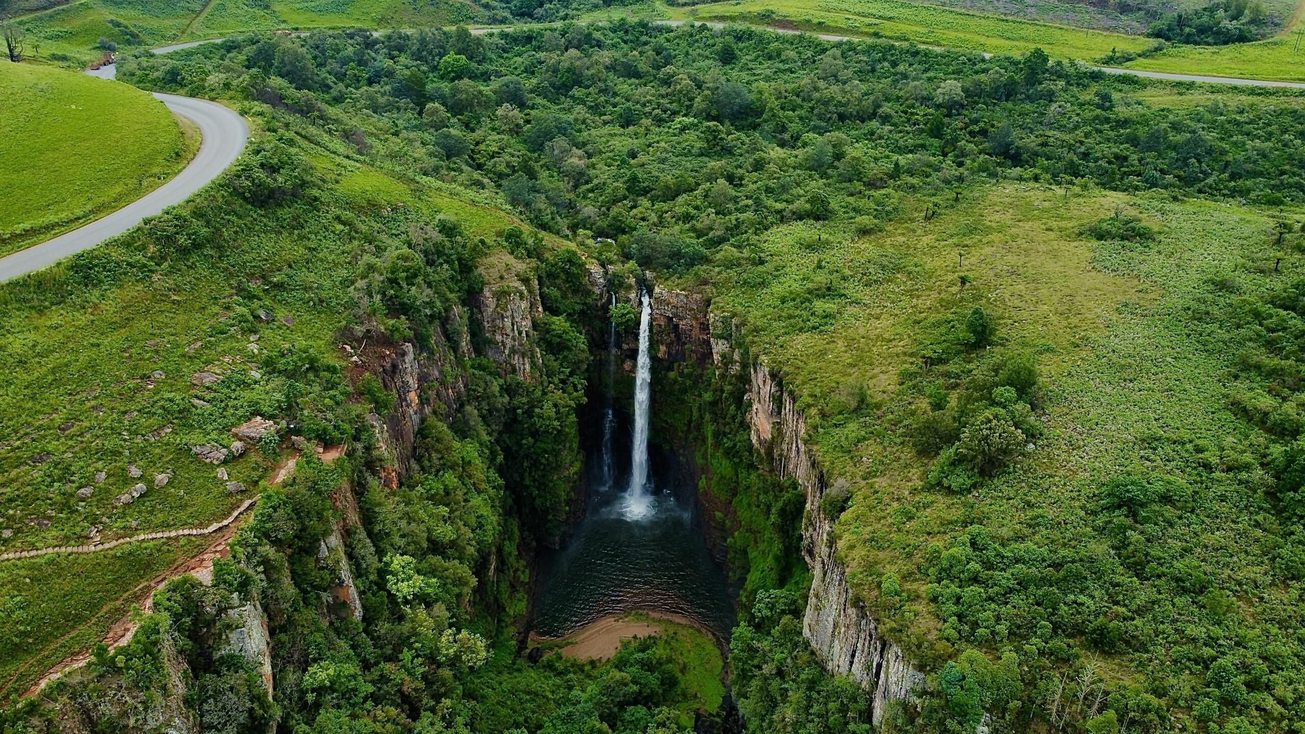
Some of the most well known South African waterfalls can be found along the Panorama Route in Mpumalanga.
Examples include:
- Lisbon Falls
- Berlin Falls
- Mac Mac Falls
Because of their accessibility, they are among the most beautiful waterfalls in South Africa and a number of boardwalks and viewpoints allow visitors to safely admire the falls and surrounding forested valleys.
Many geography teachers use these locations to explain how South African waterfalls form. When rivers flow over hard rock layers that resist erosion, the softer rock below gradually wears away. This creates a vertical drop where water cascades over the cliff.
In short, some of the most picturesque and beautiful waterfalls in South Africa also play an important role in shaping valleys and gorges.
Grasslands, Deltas, and Coastal Landscapes
Water does not only create waterfalls and canyons. As rivers reach flatter land, they slow down and deposit sediment. Over time, this forms floodplains and wetlands.
These environments support farming and wildlife, and they are another example of the diverse geographical features of South Africa.
If you are interested in how rivers create fertile landscapes, you might enjoy reading our article on the deltas and grasslands of South Africa. This companion article explores how water systems shape the ecosystems that surround them.
Grasslands across the Highveld, for instance, developed partly because of seasonal rainfall patterns and river drainage systems. These environments support livestock farming and large wildlife reserves.
If you're searching for South Africa geographical features, understanding this system will help you to connect with agriculture, biodiversity, and settlement patterns.
How Climate Shapes the Landscape
Climate also plays a major role in forming the country’s landforms. Heavy rainfall can accelerate erosion, while dry regions may preserve ancient rock formations for millions of years. This is why some South African waterfalls flow strongly during the rainy season but shrink during dry winter months.
Understanding climate also helps explain why certain regions contain clusters of beautiful waterfalls in South Africa, especially in wetter provinces like KwaZulu Natal and Mpumalanga.
You can learn more about these patterns in our article, which explains how rainfall distribution influences rivers, wetlands, and many other South African geographical features.
Learning from the Landscape
If you are a tutor, parent, or teacher, these locations offer fantastic learning opportunities.
Outdoor geography lessons allow learners to observe natural processes that are difficult to visualise in a classroom. Visiting canyons, rivers, and South African waterfalls helps bring topics like erosion, rock layers, and river systems to life.
Here are a few simple project ideas.
Geography Fieldwork Ideas
- Map the route of the Orange River South Africa from Lesotho to the Atlantic Ocean
- Photograph different South African waterfalls and compare their height and structure
- Identify rock layers in canyon walls during a hiking trip
Creative Learning Activities
- Sketch the cliffs around the Blyde River Canyon
- Create a photo essay of beautiful waterfalls in South Africa
- Write a short report explaining how water shapes landscapes
A Landscape Full of Natural Wonders
When you explore the country, it becomes clear that water and geology work together to shape extraordinary landscapes. From the cliffs of Waterfall Bluff to the vast gorge of Augrabies, the geographical features of South Africa reveal a story that stretches back millions of years.
More than scenic destinations, these remarkable geographical features are living lessons in earth science waiting to be discovered.
Summarise with AI:
Enjoyed this article? Leave a rating!